Punta Manara


Edited by:
Maurizio Loconti
Updated at: 06/10/2024
Access
You exit the Genoa-La Spezia motorway at the Sestri Levante junction and turn towards the centre. Afterwards, park your car at the first available spaces.
Introduction
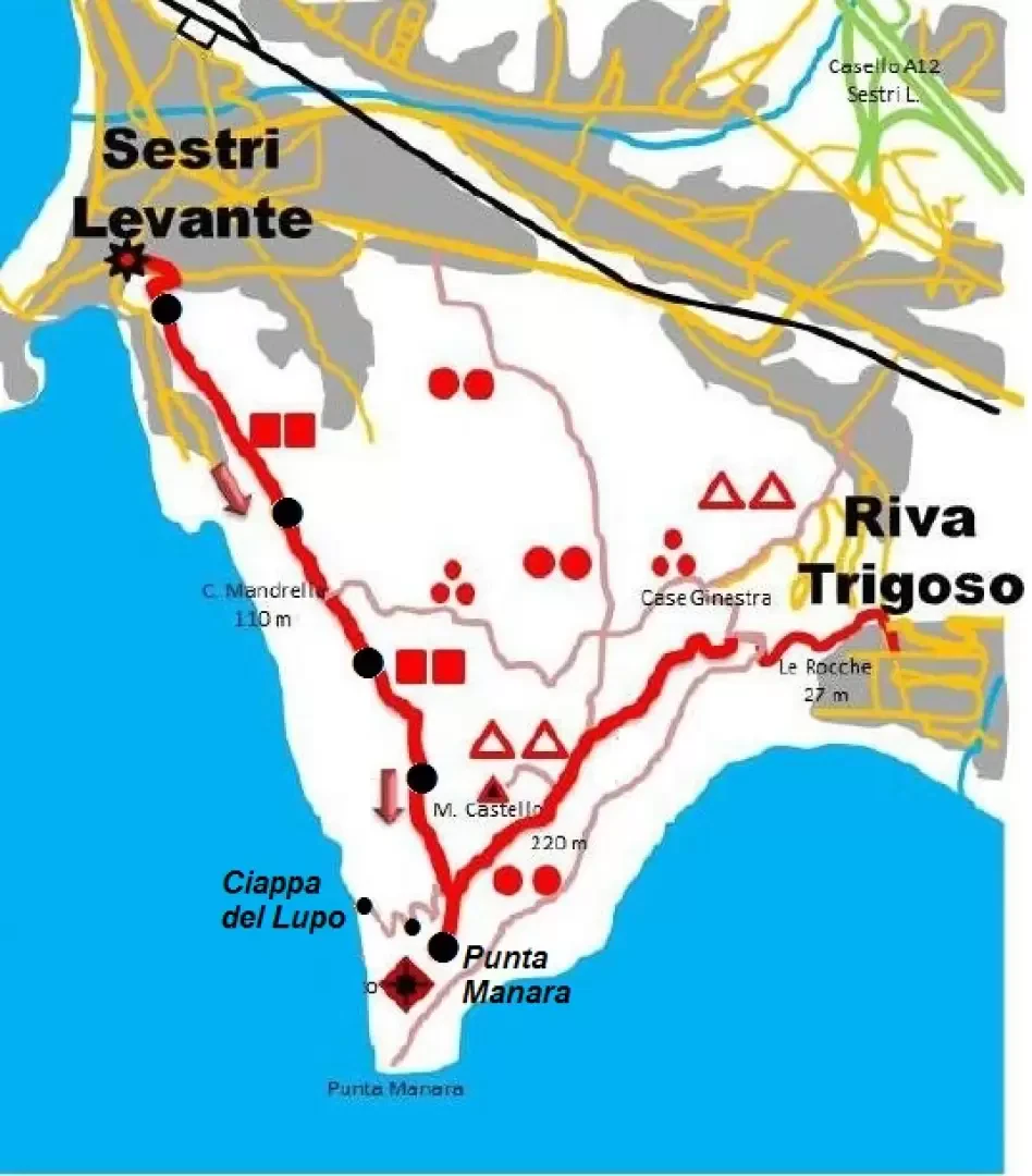
Punta Manara, is a beautiful, triangular-shaped promontory (almost 200 hectares), stretching out over the sea between the seaside resorts of Sestri Levante and Riva Trigoso. There is extensive and varied vegetation (holm oak, pine, strawberry tree, cork oak, etc.), which makes the area very pleasant, especially in the period from autumn to spring.
Description
Park your car on the outskirts of Sestri Levante and head for the town's pedestrian zone (15'). From Via XXV Aprile, you turn left into a lane (vico del bottone - vertical signs and Fie symbols two red squares) that then climbs between high walls to the heights of Sestri, amid vegetable gardens and olive groves. If you turn back, the view of the Gulf of Silenzio and the Tigullio coast is truly splendid. After about 30', at a crossroads, we climb to the right among the strawberry trees. From here, a series of signs tell of the flora present in the area. After gaining height, with a series of steps in the rock, the path flattens out and you come to another obvious fork (40'). To the left, one goes to Riva Trigoso, while to the right there is a construction, used as a bivouac, with some benches and tables (but in a shady area). Beyond the construction, a steep flight of steps (be careful going downhill) immediately leads to Punta Manara (166 m), with the remains of a watchtower (the symbols continue for a few more metres on a small path where caution is required - 5'). The panorama is vast and impressive, in all directions! After the stop, head back (ignoring the fork x Riva Trigoso) towards Sestri Levante, but only for a few metres. In fact, we notice a rock on the ground, with old hiking symbols, and a tree, on the left, with an obvious coloured stripe (photo 23). From here (a barely visible branch), it is possible to descend to the left on a track, without any markings, towards the sea. Immediately at a fork, we turn decisively to the right (photo 24) descending with frequent switchbacks (some very steep! And therefore to be done slowly...) and always following the most evident path. We continue to lose altitude and the sound of water crashing on the shore becomes loud. After a slightly steeper section, you can see the sea and the ledge cuts the slope level (to be done carefully!). With a final, somewhat technical descent, you conquer the rocky slab (25') that leans towards the water (to be avoided in rough seas). The place is called "Ciappa del Lupo", perhaps because the spot is a little isolated...
After a long break, we climb the approximately 150 m difference in altitude in 35' (the ascent is more strenuous, but less demanding than the descent, so the two times are almost equal). Once on the main track, you turn left and, in 1h, you return to the centre of Sestri Levante and from there to your car (15').
In short: 3h30 - 4h, for about 350 m of altitude difference. Diff. T or a little more on the basic route, almost EE for the descent to the sea from Ciappo del Lupo (so on average E).
if you want some photos are at the http://www.cralgalliera.altervista.org/anno2013.htm link to the corresponding link
NB: in case of an excursion, always check with FIE, Cai, any park authority or other institutions, pro loco, etc., that there have been no changes that have increased the difficulties! No liability is accepted. This text is purely indicative and not exhaustive.
Info Hiking Section Cral Galliera: http://www.cralgalliera.altervista.org/esc.htm
General information
Trail:from Sestri Levante
Signposts:two red squares and path without symbols
Type of route: a/r
Recommended period:October, November, December, January, February, March, April
Sun exposure:West
Objective Danger:the descent to the sea from Ciappo del Lupo is almost EE
Exposed sections: -
Useful equipment: -
Water: -
Photo gallery


Comments (0)
Sign in to leave a comment