Annecy

Edited by:
Massimo Martini
Access
The town can be reached via the motorway, which links Grenoble and Chambéry in the south with Geneva in the north, via the Annecy-Nord and Annecy-Sud exits. From the town, the departmental roads lead towards Aix-les-Bains and Chambéry, towards La Roche-sur-Foron and the Arve valleyArve Valley, along the western shore of the lake towards Faverges and Albertville, and along the eastern shore towards Veyrier-du-Lac and Thônes; the climbs from Seynod to Semnoz. Annecy station is served by SNCF Voyageurs with TGV INOUI services to Paris, Auvergne-Rhône-Alpes regional TER trains to Aix-les-Bains, Chambéry and Lyon, and Léman Express trains to Annemasse and Geneva. Urban and inter-city public transport in the Greater Annecy area is operated by SIBRA (Société Intercommunale des Bus de la Région Annécienne). The nearest airport with scheduled flights is the “Aéroport international de Genève”. The Semnoz road may be subject to restrictions during the winter season.
Introduction
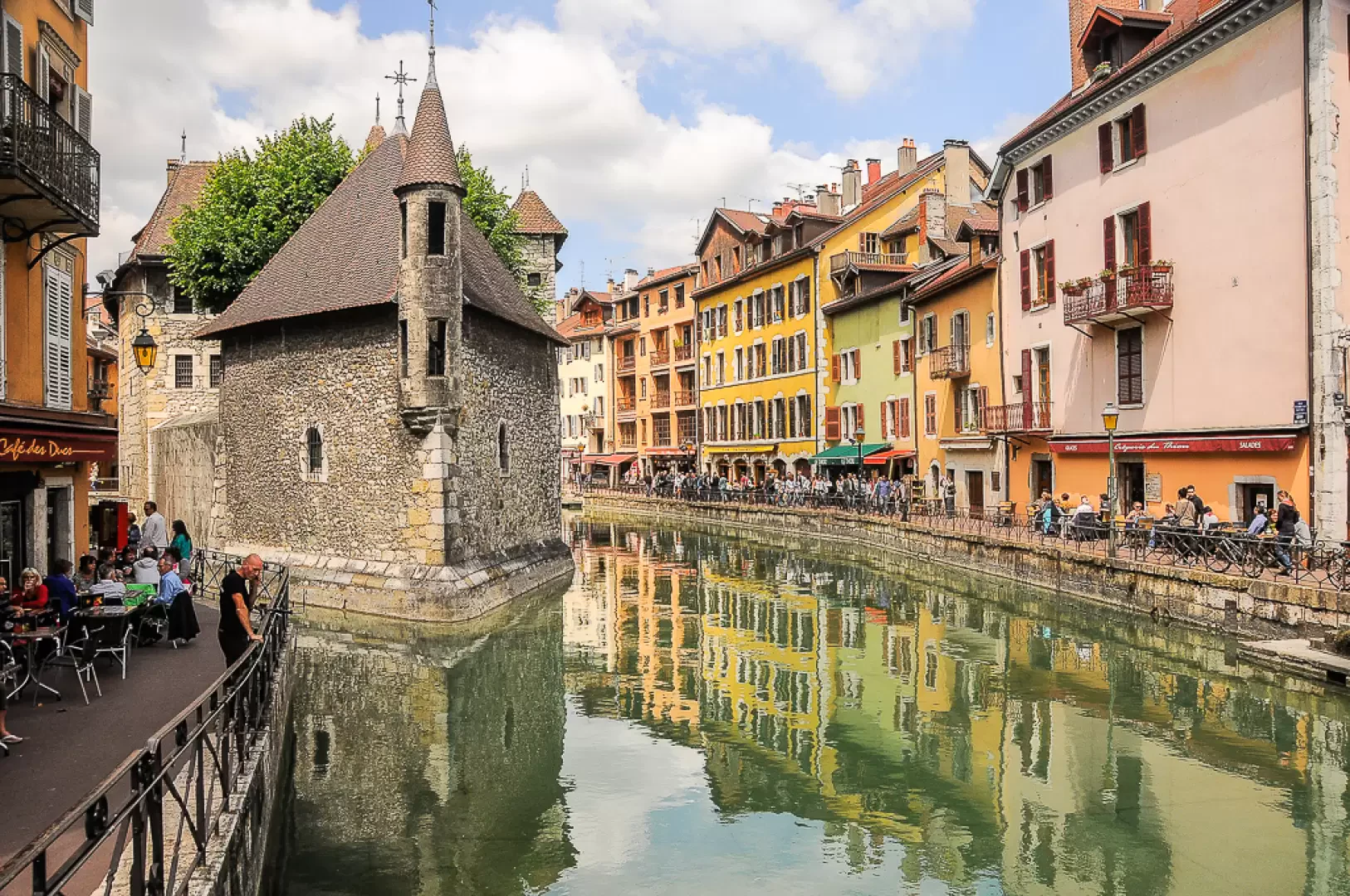
Annecy is the capital of the department ofHaute-Savoie, in the Auvergne-Rhône-Alpes region, and lies on the northern shore of the lake of the same name, at the point where the Thiou, the lake’s outlet, flows through the town before joining the Fier. The current municipality was formed in 2017 through the merger of Annecy with Annecy-le-Vieux, Cran-Gevrier, Meythet, Pringy and Seynod. The area comprises the plain to the north and west, the moraine hill of Annecy-le-Vieux to the east and the lower slopes of the Semnoz to the south-west, and rises from just under 400 metres, along the River Fier, to over 1,100 metres on the slopes of Mont Veyrier. It borders seventeen municipalities, including Épagny-Metz-Tessy and Argonay to the north, Sévrier and Veyrier-du-Lac – with which it shares the waters of the lake – and Quintal and Viuz-la-Chiésaz on the Semnoz. The historic centre, criss-crossed by canals, lies at the foot of the castle of the Counts of Geneva.
Description
The municipal area stretches from the northern shore of Lake Annecy to the Fier Valley, which forms part of its north-western boundary. To the north and west lies the plain on which the districts of Meythet, Cran-Gevrier and Pringy are situated; to the east, the hill of Annecy-le-Vieux – a moraine left behind by Quaternary glaciers – rises towards the foothills of Mont Veyrier; to the south-west, the hills of Seynod lead up to the Semnoz massif. The lake, of glacial origin, is fed by streams and sublacustrine springs; the southern boundary of the municipality with Sévrier and Veyrier-du-Lac runs beneath its waters. The Thiou, the lake’s outlet, flows through the historic centre, where, together with the Vassé and the Saint-Dominique Canal, it feeds the old town’s network of canals, before joining the Fier at Cran-Gevrier.
Remains of lake-dwelling villages dating from the 3rd millennium BC have been discovered at Annecy-le-Vieux and in the harbour area. In Roman times, the Gallo-Roman vicus of Boutae developed on the Fins plain. The medieval village grew at the foot of the castle, which between the 12th and 13th centuries became the residence of the Counts of Geneva. With the death of Robert of Geneva, who was elected antipope under the name of Clement VII, the family line died out in 1394, and in 1401 the county was purchased by Amadeus VIII of Savoy; in 1434, Annecy became the administrative centre of the Genevese and Faucigny appanages. Following Geneva’s adoption of the Reformation in the 1530s, the Bishop and the Chapter of Geneva moved to Annecy, which became a centre of the Counter-Reformation: it was here that Francis de Sales, Bishop of Geneva, resided; in 1610, together with Jeanne Françoise de Chantal, he founded the Order of the Visitation. In 1792, the town was incorporated into the French department of Mont Blanc; having returned to the House of Savoy following the Restoration, it became the seat of the Diocese of Annecy in 1822 and was annexed to France in 1860 under the Treaty of Turin. Its historical heritage includes the castle, the Palais de l’Isle, built on a small island in the River Thiou and used over the years as a residence, mint, court and prison, St Peter’s Cathedral, the Collegiate Church of Notre-Dame-de-Liesse, the Church of St Francis – rebuilt in 1642 to house the tombs of the founders of the Order of the Visitation – and the Basilica of the Visitation, located outside the historic centre, where their relics are now enshrined.
The industrial development that followed the annexation relied on the hydraulic power of the River Thiou, along which paper mills – which later became Aussedat – had been operating since the 15th century. In the 20th century, the precision engineering sector flourished, with the production of ball bearings by SNR, alongside sports equipment manufacturers, including Salomon and Mavic. Lake and mountain tourism, the University of Savoie Mont-Blanc and the service sector round off the economic landscape. Annual events include the International Animation Film Festival and the Fête du lac. The town is the start and finish point for the MaXi-Race, a trail running race along the ridges around the lake: in the2026 edition, the Tour du Lac covered 100–105 km with 5,700–6,100 m of elevation gain, whilst the Marathon-eXpérience covered 38–42 km with 1,600–1,800 m of elevation gain.
The lake’s waters have returned to an oligotrophic state following the construction of the sewerage system encircling the lake, initiated by the inter-municipal association of the lakeside municipalities – now known as SILA, founded in 1957 – and completed in 1976. Commercial fishing focuses on whitefish (Coregonus lavaretus), the Arctic char (Salvelinus alpinus), perch (Perca fluviatilis), lake trout (Salmo trutta) and the pike (Esox lucius). Along the banks grow common reed (Phragmites australis) and the yellow water lily (Nuphar lutea); the reed beds are home to the little bittern (Ixobrychus minutus).
The network of walking trails starts directly from the town. To the east, the paths climb from Annecy-le-Vieux to Mont Veyrier, via the Col des Contrebandiers, which is closed to motor vehicles; to the south-west, from the Grande Jeanne area, the route climbs the wooded slope of the Semnoz to the summit plateau, which can also be reached by road. The first stage of the GR des Grands Lacs starts from Annecy, following the Semnoz ridge towards Leschaux. A cycle route of around 40 km runs around the lake, with a dedicated cycle path along the western shore.
Information
General information
Area: 66.93 km²
Altitude of the main town: 448 m
Highest point: 1,153 m – slopes of Mont Veyrier
Population: 132,117 (as at 1 January 2023)
Name in the local dialect: Ènneci, in Arpitan
Name of the inhabitants: anneciani
Patron saint: Saint Francis de Sales, celebrated on 24 January
Neighbouring municipalities: Alex – Argonay – Chapeiry – Chavanod – Cuvat – Dingy-Saint-Clair – Épagny-Metz-Tessy – Fillière – La Balme-de-Sillingy – Montagny-les-Lanches – Nâves-Parmelan – Poisy – Quintal – Sévrier – Veyrier-du-Lac – Villaz – Viuz-la-Chiésaz
Department: Haute-Savoie
Region: Auvergne-Rhône-Alpes
Country: France
Official website: annecy.fr