Bourg-Saint-Pierre

Edited by:
Massimo Martini
Access
Bourg-Saint-Pierre can be reached from Italy via the motorway exit at Aosta Ovest, which leads onto the slip road for the Great St Bernard Road; the state road runs up the Valpelline and the Great St Bernard Valley, passing through Gignod, Étroubles, Saint-Oyen and Saint-Rhémy-en-Bosses. Just before the latter village lies the Italian entrance to the Great St Bernard Tunnel, a toll road, which emerges at Bourg-Saint-Pierre on the Swiss side at an altitude of 1,918 metres. In the summer months, the SS27 continues as a mountain pass road to the Great St Bernard Pass (2,469 m), which is generally open from late May/June to October depending on snow conditions; beyond this point, the road continues as the Swiss main road . From Switzerland, access is via the Lausanne–Sion–Briga motorway, taking the Martigny exit, then continuing on the through Sembrancher, Orsières and Liddes. The nearest railway station is Martigny, on the Simplon line operated by Swiss Federal Railways (SBB), from where you continue on the Martigny–Orsières regional train, changing at Sembrancher, and finally on the Orsières–Bourg-Saint-Pierre–Great St Bernard Pass bus route operated by Transports Martigny Région SA (TMR), which runs less frequently during the winter months. During the winter months, winter tyres or snow chains are required throughout the valley, and the Great St Bernard Pass remains closed to road traffic from late autumn to late spring.
Introduction
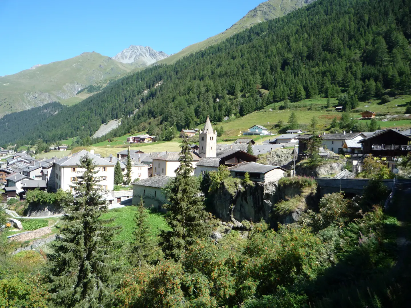
Bourg-Saint-Pierre is the last municipality in the Entremont Valley before the Great St Bernard Pass, in the district of the same name in the Canton of Valais, on the border with the Aosta Valley. The village, the only significant settlement within the municipal area, lies at an altitude of 1,632 metres, making it the highest inhabited settlement in the entire valley. The municipal area stretches from the valley floor, through which the Dranse d’Entremont flows, up to the glacial heights of the Grand Combin massif, and also includes the historic Great St Bernard Hospice, situated at the pass. The municipality’s identity is shaped by its role as an Alpine transit route, which has been in continuous use since Roman times along the axis linking the Po Valley to the Rhône basin.
Description
The municipal area lies at the head of the Entremont Valley, stretching from the valley floor – through which the Dranse d’Entremont flows – up to the glacial ridges that mark the border with Italy. Around two-thirds of the municipal area consists of rock, glaciers and unproductive high-altitude pastures, whilst areas used for hay and grazing occupy just under a third of the territory and woodland makes up the remainder. The Tseudet and Valsorey glaciers, on the Mont Vélan and Grand Combin massifs, feed the streams that flow into the Dranse. The narrow, deep valley floor widens only at the main settlement, whilst the rest of the territory rises rapidly to mountaineering altitudes.
The village is first mentioned in records in 1125 under the name Burgus Sancti Petri and owes its origins and name to its location along the transit route to the mountain pass, which was already in use in Roman times: at the foot of the bell tower – the oldest in the Canton of Valais – a Roman milestone dating from the 4th century is preserved. In the Middle Ages, the village was a stop on the Via Francigena, the pilgrimage route to Rome. In May 1800, Napoleon Bonaparte’s army crossed the pass via Bourg-Saint-Pierre during the campaign leading up to the Battle of Marengo, an event that remains one of the most famous in the local history of the pass.
For centuries, the municipality’s economy was linked to alpine grazing and the provision of guides for travellers heading for the pass, in a context where agricultural resources were limited by the altitude and the narrowness of the arable land in the valley floor. Today, agro-pastoral activities coexist with small-scale tourism, focused mainly on mountaineering and ski mountaineering, whilst the resident population has remained stable at modest levels over the last few decades.
The natural environment is typical of the high Alpine region, with grasslands, rocks and glaciers that are home to wildlife adapted to the harsh climate; the Great St Bernard area is known for its population of ibex (Capra ibex). The village and the pass area are included in the Federal Inventory of Swiss Settlements to be Protected, aimed at safeguarding the historic built heritage.
Bourg-Saint-Pierre is a classic starting point for mountaineering in the Grand Combin massif and on Mont Vélan, towards the Swiss Alpine Club huts at Valsorey and Vélan, and is a stop on multi-day routes such as the Tour des Combins and the Tour du Saint-Bernard, as well as the Via Francigena. In winter, the village is a starting point for ski mountaineering, with a link to the Chamonix–Zermatt Alta Via, and for snowshoe trails signposted from the village.
Information
General information
Area: 90.2 km²
Altitude of the main town: 1,632 m
Highest point: 4,314 m – Grand Combin de General information
Area: 90.2 km² Altitude of the main town: 1,632 m Highest point: 4,314 m – Grand Combin de Grafeneire
Population: 222 (as at 31 December 2024)
Name in the local dialect: Lo Bôrg (in Arpitan/Valaisan Patois)
Name of inhabitants: bordillons
Patron saint: Saint Peter, celebrated on 29 June
Neighbouring municipalities: Bagnes– Liddes – Orsières – Municipality of Étroubles, Italy (Aosta Valley) – Municipality of Ollomont, Italy (Aosta Valley) – Municipality of Saint-Oyen, Italy (Aosta Valley) – Municipality of Saint-Rhémy-en-Bosses, Italy (Aosta Valley)
Canton: Canton of Valais
Country: Switzerland
Official website: www.bourg-saint-pierre.ch