Ru Chandianaz, from Chambave

Edited by:
Massimo Martini
Updated at: 04/05/2025
Access
Leaving the motorway at the Châtillon exit, take the and continue in the direction of Aosta. After a few kilometres you will reach the municipality of Chambave: at a large crossroads, turn right and go up a small uphill road to the car park in front of the Crotta de Vegneron.
- How to get there with GMAPS
- How to get there with Apple Maps
The information provided here has been verified as of the date of the route survey. Before setting off, it is advisable to ensure that no substantial changes have occurred on the route to the starting point. We therefore recommend the use of the satellite navigation apps provided by Google or Apple for up-to-date and detailed directions.
Introduction
A pleasant walk with no particular difference in altitude on the sunny slope between Châtillon and Chambave.
The Ru Chandianaz is a small irrigation canal that carries meltwater from the glaciers of Mount Cervino to the steep sunny slopes of the Dora Baltea valley.
Unlike Ru Marseiller, which runs about 300 metres higher up, it is not possible to walk along its entire route from the intake works because the first section has been piped and the canal's water only returns to the surface at the entrance to Valtournenche, above Gamba Castle in Châtillon.
Tracing the route of Ru Chandianaz is guaranteed to be a pleasant walk. You start at the beginning of Valtournenche, near the old lime kiln, pass by the village of Farys where a vine that is more than three centuries old still bears fruit, then from the village continue on to Chambave among the vineyards where the famous Muscat is born.
Description
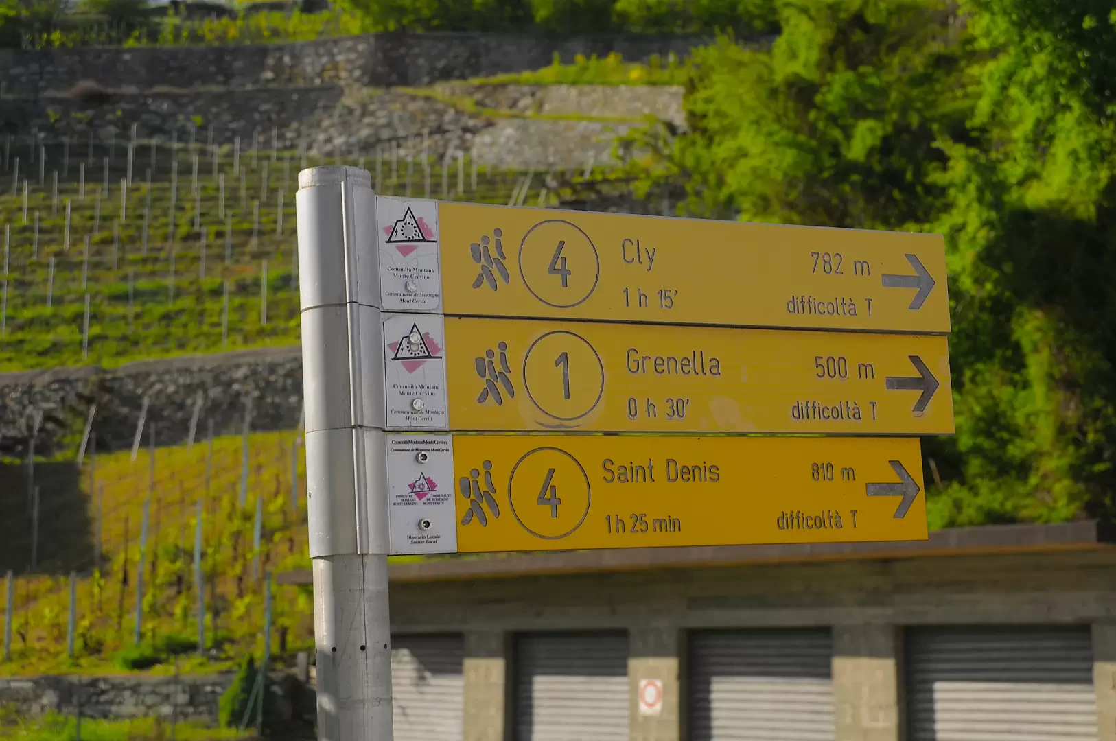
0h00' From the car park, turn first right and then left before reaching the signpost indicating the start of the path . Follow the indications on the signpost by taking a small road on the right that runs alongside a stream and cross it, turning right over a small concrete bridge. You soon reach the hamlet of Barmet, where you turn left at a yellow marker and enter the small hamlet. After a turn to the right, the path begins to climb up the ridge on a wide paved road; after a few minutes we come to the first of the signposts that will accompany us along the entire route: near the signposts there are also comfortable benches to enjoy the view. After a few hairpin bends we come to a small cave (barma) and, continuing along the path lined with beautiful dry stone walls, we join a small tarmac road (560 m, 0h15'), which we leave at a high-tension pylon, turning left.
0h15' We begin to climb first up a small road then, turning right, a path that crosses the Muscat de Chambave vines, reaching a small oratory, an ancient vestige of popular devotion. Continuing the ascent, we enter the wooded scrub composed of downy oaks (Quercus pubescens), until we come to a small waterfall: these are the runoff waters of the ru Chandianaz, which are taken from the valley of the Matterhorn and provide irrigation for the rugged slopes of Chambave and Saint-Denis. Just above, we meet the start of the path that runs alongside the ru just mentioned: we overlook this path, which branches off to the right, and continue straight on until we reach a tarmac road again and shortly afterwards the village of Cuignon (678m, 0h30').
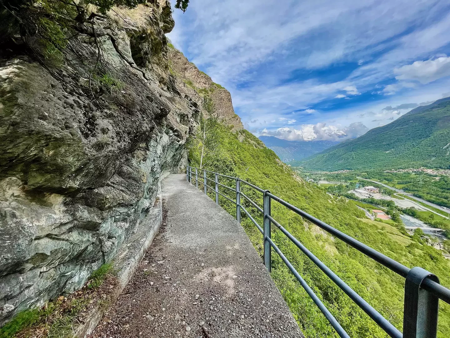
The first half of the itinerary has some exposed points, while the second is relatively safer. As is the case with almost all walks in the Aosta Valley, it often happens that you pass at the foot of rock faces that can unload stones or small landslides. Being aware of the dangers does not prevent you from walking these beautiful routes.
Description from the kiln to Farys
Those who walk through Valtournenche will notice a singular tower made of bricks and stone between Châtillon and Antey. This building has nothing historical about it, it was not a castle or watchtower but simply a lime kiln that was probably abandoned in the second half of the 20th century.
This is where the walk along the Ru Chandianaz starts. You leave your car a little further uphill on the side of the regional road then descend along the asphalt road, pass the foot of the kiln and take the small path that climbs to the right and continues almost level along the Ru Chandianaz track.
Nothing reveals the presence of water except for the inspection manholes. The initial part has all been piped. This saves on maintenance, leaves do not have to be removed from the riverbed, stones and branches do not obstruct the water course. On the other hand, tourists are deprived of the pleasure of strolling in the shade of the chestnut trees accompanied by the murmur of the water.
In Switzerland, the two opposing needs are reconciled by renaturalising some sections of these small irrigation canals: the pipes are removed where they were laid and the ru is restored to its primitive condition, in the knowledge that the higher maintenance costs will be covered by the higher income that the tourist sector guarantees compared to the agricultural sector. Here again, the writings of Emile Chanoux, who in the first half of the 20th century pointed to Switzerland as an example to follow for the development of the Valle d'Aosta, are prophetic.
Walking along the wide track covered by grass and bushes, one can see numerous points of interest: right at the beginning, turning northwards, one can see Punta Cian in the distance, a mountain considered by mountain guides to be the entrance exam for the ascent of the Matterhorn. The last queen of Italy, Maria José, climbed it precisely in preparation for that much more demanding ascent. On the other side of the valley, one can see the penstocks of the Covalou hydroelectric power station and the remains of the Ru du Pan Perdu of Châtillon, one of the many irrigation canals built in the Middle Ages and then abandoned.
Upstream of the track, one can observe the various methods used to limit the natural crumbling of the mountains: rockfall nets, the covering of the steepest slopes, walls made of metal gabions. All of these works were built to limit in some way the damage caused by rockfalls, which, in a region like the Aosta Valley with an average height of around 2100 metres above sea level, can never be completely avoided.
When you get to the central valley, the ru comes out of the underground conduit and flows into the open air squeezed between the two small concrete abutments. The chestnut trees gradually give way to a vegetation of downy oaks and pines that are better adapted to the dry climate of the valley floor. From time to time one encounters the small, fragrant shrubs of thyme (Thymus vulgaris), which are covered with tiny pink flowers in spring.
Down below one can see the village of Châtillon, behind the church the historic castle with its park full of monumental trees. On the other side of the valley you can see the castle of Ussel perched on a spur of red rock. Continuing along the ru you pass just above Gamba Castle, built in the early 1900s and home to the regional art gallery.
A small metal bridge allows you to cross the last penstocks of the Valtournenche hydroelectric plants. It was on the banks of the Dora Baltea that the Breil hydroelectric power station was built. You can see the water, which has been stored in the Goillet dam at an altitude of more than 2,500 metres, gurgling in the outflow channel and, after passing through four hydroelectric plants, flows into the Dora Baltea.
At the bottom of the valley, on the left, you can see in the distance the rounded saddle that hides the Laures lakes and the Menabreaz Bivouac: a bivouac built in one of the most beautiful areas of the entire Aosta Valley that can be reached in four hours of interminable ascent.
You cross a historic landslide that looms over a handful of houses with an evocative name: Freyan. It has been suggested that the place name derives from the French word effrayant, frightening, but toponymy is not considered an exact science to this day. The settlement was once defended only by the faith of the inhabitants, who built the small chapel. In the second half of the 1900s, prayers were added to the parafrane valleys and rockfall containment nets, despite which the village below is still considered to be at risk.
Downstream of the ru path, a few sections of ancient walls can be glimpsed; they may date back to the late Middle Ages, when most of the Ru in Valle d'Aosta were built.
Before reaching Farys twice, one walks suspended over the valley floor: there are two reinforced concrete bridges that support both the pipes of the ru and the accompanying path. They are wide enough not to present an obstacle for those suffering from vertigo and protected by a metal railing to prevent falls.
Galleria fotografica