Étroubles

Edited by:
redazione
Access
Étroubles can be reached via the [A5] Turin–Aosta motorway, taking the Aosta Est exit, from where you continue north on the Gran San Bernardo road; Until June 2027, the link between the motorway and the main road is closed for tunnelling works, and the route involves travelling through the town of Aosta. The main road follows the valley upwards, passing through Gignod, and reaches the village, which lies along its route; local roads branch off from the main road to the hamlets on the hillside. The nearest railway station is Aosta, on Trenitalia’s (TI) Chivasso–Aosta line; the section between Aosta and Ivrea is closed for electrification works and is served by replacement buses, with a phased reopening scheduled to begin in January 2027. Local public transport is operated by Arriva Italia, with a suburban service running between Aosta and Saint-Rhémy-en-Bosses. The nearest airport with scheduled flights is Turin-Caselle’s “Sandro Pertini” Airport. During the winter months, the valley experiences heavy snowfall and vehicles must be fitted with winter tyres or carry snow chains.
Introduction
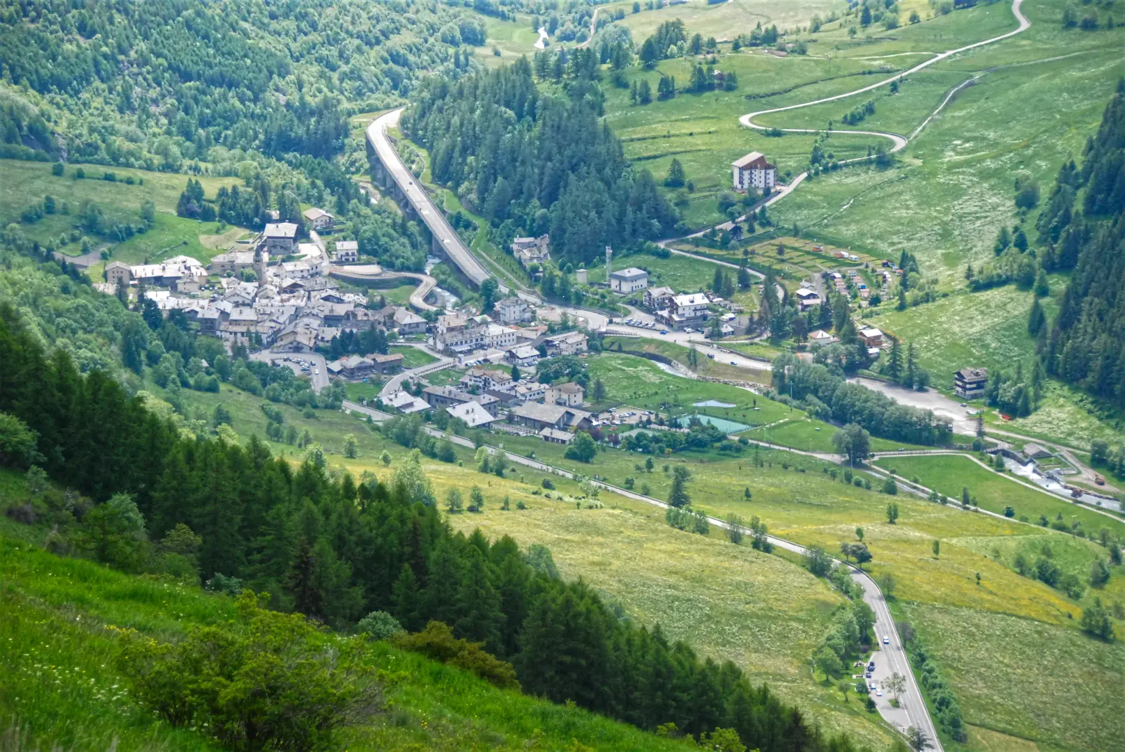
Étroubles is a municipality in the Aosta Valley, situated in the Great St Bernard Valley, halfway along the route from Aosta up to the pass and the border with Switzerland. The village lies in the valley floor along the Artanavaz stream, just below 1,300 metres, whilst the municipality’s territory extends up the slopes and side valleys to the ridge marking the border with Valais, at over 3,700 metres. The municipality borders Allein, Doues, Gignod, Ollomont and Saint-Oyen and, across the border, Bourg-Saint-Pierre. For centuries, the community’s livelihood depended on the transit route to the Great St Bernard Pass, and the village remains a stop on the Via Francigena to this day.
Description
The area extends around the middle section of the Artanavaz and includes, on the left bank, the Menouve and Molline valleys, which rise towards the border ridge dominated by Mont Vélan, where glacial remains can still be seen. The hamlets, including Échevennoz, Vachéry, Éternod, Prailles, Pallais and Bezet, occupy the terraces on the slope; higher up lie coniferous forests, mountain pastures and alpine meadows. The village retains its medieval layout, with cobbled streets, fountains and stone buildings with slate roofs.
In Roman times, the settlement, known as Restapolis, was one of the key points along the Via Gallica leading to the mountain pass and probably housed the garrison’s winter camp; some sources place the mansio of Eudracinum here, whilst others attribute it to Saint-Rhémy. The place name derives from the patois word ‘étrobla’, meaning the stubble left in the fields after the harvest, rendered in Latin as ‘Stipulis’. From 1273, the House of Savoy granted the inhabitants of Étroubles and Saint-Rhémy the exclusive right to accompany travellers and merchants over the pass: the marronniers, guides and porters, exercised this privilege until it was abolished in 1783. In 1317, a hospice for pilgrims was founded in the village. On 20 May 1800, Napoleon Bonaparte, having descended from the pass with his army, spent the night in Étroubles at the home of Abbot Léonard Veysendaz. Between 1939 and 1946, the name was Italianised to Etroble. The parish church of Santa Maria Assunta, dating from 1815, stands on the promontory of La Tour, where the tower of the de La Tour family once stood; this family died out in the mid-15th century, and its stones were reused in the church’s construction; in the main village, the 15th-century bell tower of a church that no longer exists remains. In Vachéry, the 12th-century Tour de la Vachère is preserved. Among the chapels in the hamlets, that of Échevennoz was founded in 1440 and that of Bezet dates back to 1742.
In 1853, the first communal dairy in the Aosta Valley was established in Étroubles; today it houses a museum dedicated to the production of Fontina, butter and séras. In 1904, Césarine Bertin built the hydroelectric power station that brought electricity to the valley; it has since been converted into the Energy Museum. Since 2005, the village has been home to the open-air museum “À Étroubles, avant toi sont passés...", featuring works by Italian and international artists displayed along the streets and dedicated to the theme of travel. In August, the Veillà d’Étroble takes place, a celebration of traditional crafts, and the communal baking of black bread continues in the Éternod oven; the municipality takes part in the Coumba Freida Carnival. Étroubles is part of the Unité des Communes valdôtaines Grand-Combin and the ‘Most Beautiful Villages of Italy’ network.
The area forms part of the Gran San Bernardo Valley wildlife reserve: the wooded areas are home to red deer (Cervus elaphus) and roe deer (Capreolus capreolus), whilst the rocky slopes are home to the ibex (Capra ibex) and the chamois (Rupicapra rupicapra), whilst among the birds of prey, several pairs of golden eagles (Aquila chrysaetos) nest here.
The network of footpaths links the village to the hamlets and the side valleys. In the Molline valley, along the routes of the Alta Via No. 1 and the Tour des Combins, lies the Molline Bivouac, the base for ascents of Mont Vélan from the Aosta Valley side. The valley floor is crossed by the Via Francigena, which links Étroubles to Saint-Oyen and continues towards the Great St Bernard Pass.
Information
General information
Area: 39.57 km²
Altitude of the main town: 1,270 m
Highest point: 3,722 m – Mont Vélan
Population: 484 (as at 1 January 2026)
Name in the local dialect: Étroble
Name of inhabitants: étroubleins
Patron saint: Saint Mary of the Assumption, celebrated on 15 August
Neighbouring municipalities: Allein – Bourg-Saint-Pierre (Switzerland) – Doues – Gignod – Ollomont – Saint-Oyen
Region: Aosta Valley
Country: Italy
Official website: Saint-Oyen
Aosta Valley
Country: Aosta Valley
Official website: Saint-Oyen
Aosta Valley
Country: Aosta Valley
Official website: Saint-Oyen
Aosta Valley
Country:Aosta
Country: Italy
Official website: comune.etroubles.ao.it