Saint-Rhémy-en-Bosses

Edited by:
redazione
Access
Saint-Rhémy-en-Bosses can be reached via the [A5] Turin–Aosta motorway, taking the Aosta Est exit, from where you continue north on the Gran San Bernardo road; until June 2027, the link between the motorway and the state road is closed for tunnelling works, and the route passes through the city of Aosta. The state road winds up the valley, passing through Gignod, Étroubles and Saint-Oyen, before reaching the municipal area, where it splits into the slip road for the toll-paying Great St Bernard Tunnel and the road over the pass, which is only open during the summer season. The main railway station is Aosta, on Trenitalia’s (TI) Chivasso–Aosta line; the section between Aosta and Ivrea is closed for electrification works and is served by replacement buses, with a phased reopening scheduled to begin in January 2027. Local public transport is operated by Arriva Italia, with a commuter service running between Aosta and Saint-Rhémy-en-Bosses; during the summer months, a service runs to the Great St Bernard Pass. The nearest airport with scheduled flights is Turin-Caselle’s “Sandro Pertini” Airport. The valley is one of the snowiest areas in the region: during the winter months, winter tyres or snow chains must be carried in the vehicle.
Introduction
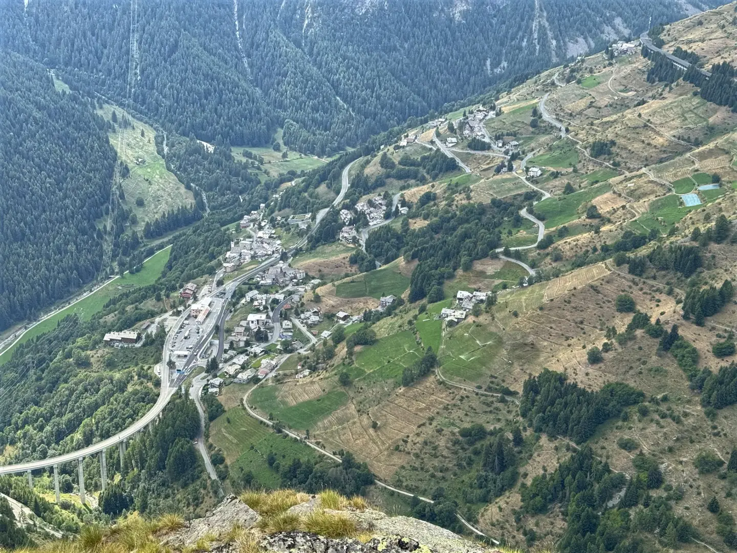
Saint-Rhémy-en-Bosses is a municipality in the Aosta Valley situated at the head of the Great St Bernard Valley, the last Italian territory along the road and tunnel route. The town hall is situated in Saint-Léonard, in the Bosses area, just over 1,500 metres above sea level, whilst the village of Saint-Rhémy lies higher up in the valley; the territory extends up to the ridges marking the border with Valais and Val Ferret, at an altitude of over 3,200 metres. The municipality borders Saint-Oyen, Gignod, Saint-Pierre, Avise, La Salle and Courmayeur and, across the border, Bourg-Saint-Pierre and Orsières. Its identity is linked to its role as the last settlement before the mountain pass, a factor which has shaped the community’s economy and traditions for centuries.
Description
The area comprises the upper valley of the Artanavaz stream, a tributary of the Buthier, stretching from the valley floor at Bosses to the basin preceding the Great St Bernard Pass, as well as the side valleys that rise up to the border ridges: towards the Valais to the north and towards the Grand Golliat ridge, which separates the valley from the Val Ferret to the west. The Italian entrance to the Great St Bernard Tunnel is situated within the municipal area. The sun-facing slopes of the Tête de Crévacol are home to the ski area; the rest of the territory alternates between woodland, mountain pastures and high-altitude landscapes. The main villages are Saint-Rhémy, Saint-Léonard, Prédumaz-Falcoz and Ronc.
In Roman times, under the name Endracinum, the site was home to a mansio positioned to control the mountain pass road, whilst a villa stood on the nearby hill; some sources attribute the location of this station to Étroubles. Tradition links the village’s name to Saint Remigius, Bishop of Reims. Around 990, Archbishop Sigeric of Canterbury recorded the locality, under the name Sce Remei, as the forty-eighth stage of his journey to Rome, the route that would later be known as the Via Francigena. The Counts of Savoy granted the inhabitants the exclusive right to escort travellers and goods from Aosta to the mountain pass, as attested in the charter of 1273: from this privilege arose the marronniers, guides and porters. In 1627, Duke Carlo Emanuele I granted exemption from military service, giving rise to the ‘soldats de la neige’, who were tasked with maintaining the mountain pass road and assisting travellers. In May 1800, Napoleon Bonaparte’s troops marched through the valley on their way to Marengo. Between 1939 and 1946, the name was Italianised to San Remigio; restored as Saint-Rhémy, it took on its current form in 1991. The de Bosses family, who have lived here since the 13th century, gave their name to Bosses Castle, situated next to the church of Saint Leonard: the building, with a rectangular plan and a single-block structure featuring cross-vaulted windows, owes its present form to the 15th century, after the bailiff of Aosta had the tower demolished in 1300. In the hamlet of Les Maisons, the fortified house of Chez-Vuillen, with its cylindrical tower and machicolation, is still standing; the church of Saint Remigius, in the village of Saint-Rhémy, dates from the 18th century, whilst that of Saint Leonard dates from the 19th. Above Saint-Rhémy, the remains of the Alpine Wall defences, known as the Wall of San Remigio, can still be seen.
The village’s economy has long been linked to traffic passing through the pass; following the opening of the tunnel in 1964, many residents found work in Switzerland. The municipality is the sole production area in the Aosta Valley for ‘Jambon de Bosses’ PDO, a raw ham flavoured with mountain herbs and matured in hay, which was awarded PDO status in 1996. The Crévacol ski area offers slopes up to an altitude of around 2,400 metres. On 5 August, the pilgrimage of Our Lady of the Snows takes place at the sanctuary of Fonteinte; the municipality takes part in the Coumba Freida Carnival and is a member of theUnité des Communes valdôtaines Grand-Combin.
The high-altitude habitats of the Great St Bernard Pass are a Site of Community Importance within the Natura 2000 network (code IT1205020). The area also forms part of the Gran San Bernardo Valley wildlife reserve, home to red deer (Cervus elaphus) and roe deer (Capreolus capreolus) in the wooded areas, the ibex (Capra ibex) and the chamois (Rupicapra rupicapra) on rocky slopes, and several breeding pairs of golden eagles (Aquila chrysaetos).
The network of footpaths includes the section of the Alta Via No. 1 which climbs from the village to the Col de Malatrà, towards the Val Ferret, and a section of the Tour des Combins between Italy and Switzerland. From the village of Saint-Rhémy, you can reach the Pier Giorgio Frassati mountain refuge. The slopes of Crévacol are also traversed on ski mountaineering equipment, and the valley floor is crossed by the Via Francigena, which climbs to the pass along the route of the Roman road.
Information
General information
Area: 64.88 km²
Altitude of the main town: 1,519 m
Highest point: 3,237 m – Grand Golliat
Population: 353 (as at 1 January 2026)
Name in the local dialect: Sèn Rémi eun Boursa
Name of the inhabitants: Saint-Rhémiars
Patron saint: Saint Leonard of Noblac, celebrated on 6 November
Neighbouring municipalities: Avise – Bourg-Saint-Pierre (Switzerland) – Courmayeur – Gignod – La Salle – Orsières (Switzerland) – Saint-Oyen – Saint-Pierre
Region: Aosta Valley
Country: Italy
Official website: Aosta
Country: Italy
Official website: Aosta
Country: Italy
Official website: Aosta
Country: Italy
Official website: Aosta
Country:Aosta
Country: Italy
Official website: comune.saintrhemyenbosses.ao.it